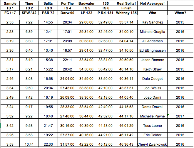
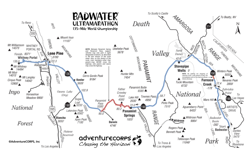
Badwater Basin, Death Valley (282ft / 85.5m below sea level), Mile Zero (Start Line)
The race begins here adjacent to a pool of saltwater located at the lowest place in North America. There are toilets, but no other services.
Furnace Creek Ranch (170’ / 51m below sea level), 17.5mi / 28.2km (Time Checkpoint #1)
The first oasis in our journey. Two hotels, gas station, general store, restaurants, camping, and ice are available. Stock up here on ice, water, food, supplies, and gas both before the race and when you pass through during the race!
Stovepipe Wells (Sea Level), 42.2mi / 68km (Time Checkpoint #2)
A general store, gas station, restaurant and motel. Location of the race’s Medical HQ for most of first 15 hours of the race. It is critical that you stock up on ice, water, food, supplies, and gas when you pass through here during the race!
Towne Pass (4956’ / 1511m), 58.7mi / 94.5km (Time Checkpoint #3)
From Stovepipe Wells, it’s 17-mile long ascent with 5000’ of elevation gain to the highest point of the race course. There are two important landmarks along the ascent: 1) The 2000′ Elevation Sign located at Mile 50.8, which must be passed by ALL runners by 1000am on the first morning of the race. 2) The Wildrose Parking Lot on the right at Mile 51.2, with lots of space for support crews to park, plus toilets.
After cresting the Towne Pass summit and passing Time Checkpoint #3, it’s a 10-mile long descent with 3000’ feet of elevation loss into the Panamint Valley. On both sides, it’s a steep and narrow road with limited opportunities to park. Support vehicles, crews, and runners must be cautious and extra aware of the traffic.
Panamint Springs Resort (2000’ / 610m), 72.7mi / 117km (Time Checkpoint #4)
Gas station, mini-mart, plus restaurant and motel. We rent out “The Cottage” as a way station for any and all race entrants and crews to use during the race: Bring your own towel, soap, and shampoo and make a big effort to keep the room and bathroom tidy. It is critical that you stock up on ice, water, food, supplies, and gas when you pass through here during the race! (Get some real food for both runners AND crew!)
After passing Panamint Springs, a long, steep climb follows on a steep and narrow road with limited opportunities to park. Support vehicles, crews, and runners must be cautious and extra aware of the traffic, and ONLY park in the eight designated parking zones between Panamint Springs Resort and unmarked “Panamint Pass” at mile 84.9. This is known as the Father Crowley Climb.
Father Crowley’s Turnout (4000’ / 1219m), 80.65mi / 130km
The bathrooms and parking lot that designate this viewpoint are not the top of this ascent, though you may hope so. The road continues to rise to 5000’ / 1524m over rolling hills, then eventually descends into the Owen’s Valley.
Darwin Turn-Off (5050’ / 1540m), 90.7mi / 146km (Time Checkpoint #5)
There are no services here, but just a few miles to the south of our route is the small inhabited ghost town of Darwin, the website for which touts “NO broadcast TV; NO AM/FM radio, NO cell signal; NO stores; NO restaurants.” The Darwin time station is where the race usually starts to get serious for all entrants. Look for “gunsite notch” about 9.3 miles ahead to indicate your 100-mile mark! The generally flat or slightly downhill stretch ahead can be tedious and demoralizing; Mt. Whitney is visible ahead and never seems to get closer! See a video of this location.
Keeler (3610’ / 1100m), 108.4mi / 174km (Time Checkpoint #6)
This is a small mining town with no facilities which abuts the Owens Dry Lake Bed on the left of the highway. Amazing views of Mt. Whitney and the Sierra Nevada abound. A dirt road to the right ascends to Cerro Gordo, an authentic ghost town high in the mountains.
Lone Pine (3610’ / 11km), 122.7mi / 197.5km (Time Checkpoint #7)
Lone Pine offers the weary runner and crew all the amenities of a real town: café fare, fast food, pizza, restaurants, motels, gas stations, a grocery store, and much more, not to mention our Race Headquarters at the Dow Villa. Restock here for the climb to Whitney Portal as there no services after Lone Pine. Turn left onto the Whitney Portal Road to begin the final leg, the longest and steepest climb of the race (13 miles or 21km with 5000 feet or 1524m of elevation gain). Temperatures will steadily decrease during the ascent (though depending on time of day). As you ascend Mt. Whitney, be sure your support vehicle is always parked completely off of the road and that you do not block traffic, not even for a moment.
Portal Road / Base of the Switchbacks (6890’ / 2100m), 131.1mi / 211km (Time Checkpoint #8)
After the turn from Hwy 395 in Lone Pine, it’s 8.3 miles or 13.4km to the final Time Checkpoint, located at the start of the switchbacks. For nighttime finishers, be prepared with extra layers of clothing; at night it can approach freezing temperature. The Portal Road is steep and very narrow: please drive and park extra carefully all the way to the finish!
Mt. Whitney Trailhead, (8360’ / 2548m), 135mi / 217km
Congratulations! You have finished The World’s Toughest Foot Race! A small burger shack / shop are open during daylight hours (and they serve the BEST pancakes, fries, and burgers.) There is also a stocked fishing pond and a campground (because, of course, after running 135 miles, you really want to go fishing and camping!).
For all the Badwater 135 race route details, click here.
Course Profile Breakdown
| Flat Miles: |
Badwater to Stovepipe Wells 41 miles |
|
| Uphill Miles: |
Stovepipe Wells to Townes 18 miles + 5,000 ft. |
|
| Downhill Miles: |
Townes to Panamint Valley 8 miles – 3,400 ft. |


