[button link=”http://www.badwater.com/wp-content/uploads/2014/06/Badwater135_2014_map.pdf”]Race Route: 2014 Edition[/button]
[button link=”http://www.badwater.com/wp-content/uploads/2014/07/Badwater135_2014_profile.jpg”]Course Profile[/button]
[button link=”http://connect.garmin.com/activity/524364463″]Garmin GPS Map[/button]
Behold the new and improved 2014 edition of the Badwater 135, the world’s toughest foot race!
Essential Race Route for 2014
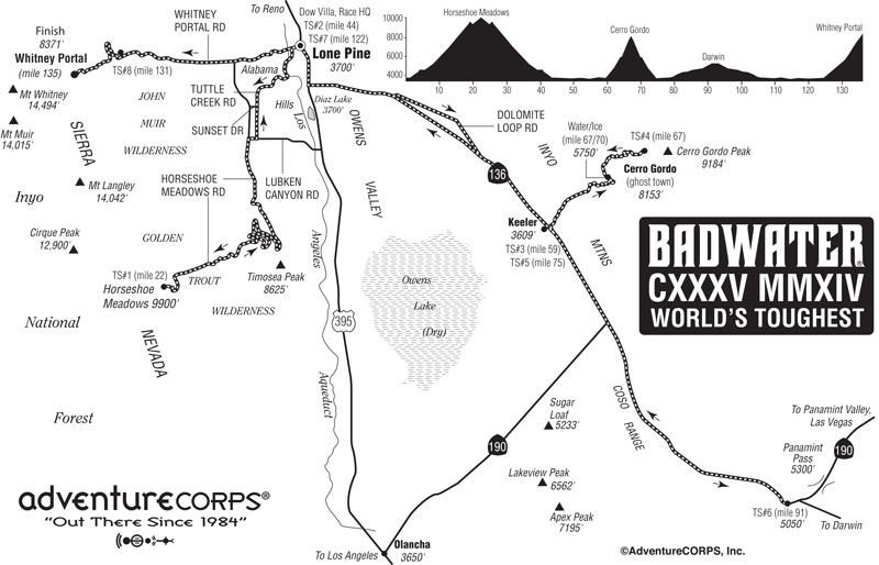
Start in Lone Pine and run up Tuttle Creek
Run to the top of Horseshoe Meadow (23 miles uphill with 6500 feet of elevation gain)
Run back down to Lone Pine
Run southeast to Keeler on Hwy 136
Run up Yellow Grade Road to Cerro Gordo (7.5 miles uphill with 5500 feet of elevation gain)
Run back down Yellow Grade Road to Hwy 136
Run southeast on Hwy 136 / hwy 190 to the Darwin Turn-Off.
Turn around and run Hwy 190 / Hwy 136 back to Lone Pine
Finish by running from Lone Pine to Whitney Portal (13 miles uphill with 5000 feet of elevation gain)
Compared to the traditional route, the 2014 version has over 17,000’ (5,200m) of cumulative vertical ascent and 12,700’ (3900m) of cumulative descent, while the traditional Death Valley-based route has 13,000’ (3962m) of cumulative vertical ascent and 4,700’ (1433m) of cumulative descent. Though the 2014 edition does not start in Badwater and traverse Death Valley and Panamint Valley, the actual topography of the new route is significantly more challenging and very much worthy of the moniker, “world’s toughest foot race.”
[anchor name=”landmarks” title=”Route Landmarks”]
2014 Badwater 135 Ultramarathon Route Landmarks
Created with GPS measurement: June 2014.
Official distance is 135.0 miles. Remember all car odometers have error. Distances above are accurate in a relative sense, but you may find variation in the overall distance, as we did when creating the above route sheet.
[button link=”http://www.spectorjosh.com/2014/06/badwater-135-recon.html” target=”blank”]>[/button] Description of the major ascents by 2014 entrant Josh Spector
[button link=”https://www.facebook.com/profile.php?id=693096313&sk=photos&collection_token=693096313%3A2305272732%3A69&set=a.10152057174796314.1073741972.693096313&type=3″]>[/button] Mile by Mile Images of the Horseshoe Meadows ascent from Mile 0 to Mile 23 by Ben Jones
[button link=”https://www.facebook.com/profile.php?id=693096313&sk=photos&collection_token=693096313%3A2305272732%3A69&set=a.10152057421061314.1073741973.693096313&type=3″]>[/button] More Images of the Horseshoe Meadows ascent from Mile 0 to Mile 23 by Ben Jones
[button link=”https://www.facebook.com/profile.php?id=693096313&sk=photos&collection_token=693096313%3A2305272732%3A69&set=a.10152164564296314.1073741991.693096313&type=3“]>[/button] Images of the Cerro Gordo ascent / descent from Mile 60 to Mile 75 by Ben Jones.
While 2014 race entrant Josh Spector and his crew trained on that stretch of the route.
Read about Cerro Gordo, the Ghost Town.
[button link=”http://www.ghosttownexplorers.org/california/cerrogordo/cg.htm”]Ghost Town Explorers[/button] [button link=”http://en.wikipedia.org/wiki/Cerro_Gordo_Mines”]Wikipedia[/button] [button link=”http://www.ghosttowns.com/states/ca/cerrogordo.html”]Ghost Towns[/button] [button link=”http://cerrogordo.us/”]Cerro Gordo[/button]
Lone Pine Map and Services Guide: a very handy reference tool for Badwater runners and crews
[button link=”http://www.badwater.com/route/LonePineGuide.pdf”]Lone Pine Guide [PDF][/button]
[button link=”http://www.lonepinechamber.org”]>[/button] Lone Pine Chamber of Commerce
[button link=”http://forecast.weather.gov/MapClick.php?site=vef&smap=1&textField1=36.56&textField2=-118.19″]>[/button] Lone Pine weather
[button link=”http://www.weather.com/weather/wxclimatology/monthly/graph/USCA0630″]>[/button] Lone Pine historical weather trend data
[button link=”http://www.weather.com/weather/wxclimatology/monthly/graph/USCA0630″]>[/button] Information about the history (1977-2013) race route


